MLPA
Where May I Surf Fish?
CA Fish and Wildlife MPA/MLPA CLICK HERE for regulations
I’ve tried to put together some common sense information about where you may and may not fish. This information is for reference purposes only. Please refer to the exact GPS coordinates as published by the California Department of Fish and Wildlife.
Not all closed areas are included here but you will find information on the following surf fishing spots:
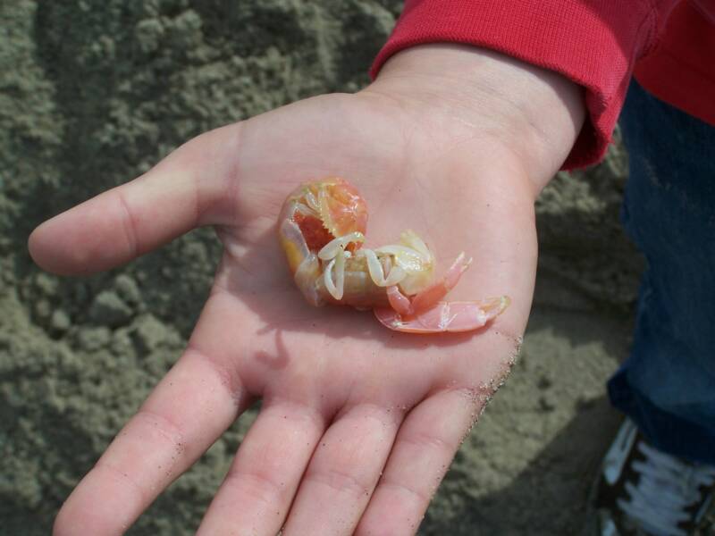
Tijuana River Mouth
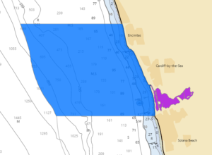
San Elijo/Encinitas
Laguna MPA Complex
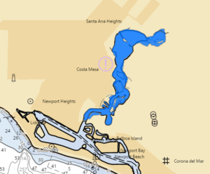
Newport Upper Bay
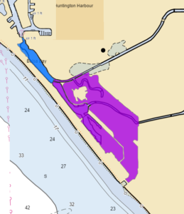
Bolsa Chica State Beach
Point Vicente/Palos Verdes
Malibu Area/Point Dume
Santa Barbara Area
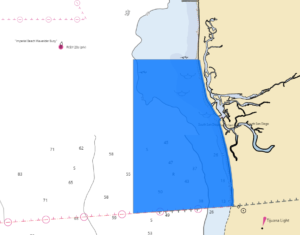


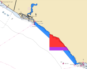
La Jolla Area The South La Jolla SMR and SMCA are to the south. Up north, the formerly well marked Scripps Ecological Reserve balloons into the new and larger Matlahuayl SMR, with the San Diego-Scripps Coastal SMCA perched above. Read on below for boundary maps and regulations.

South La Jolla SMR Southern Border (above)
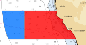
 South La Jolla SMR and SMCA Cluster – SMR no fishing; SMCA some two miles offshore allows pelagic finfish and bonito by hook and line. The boundaries are roughly Palomar Ave (north) and Diamond St (south), with the Crystal Pier shown for perspective. On the north end, the MLPAI map shows Big Rock in the closed area just south of the boundary, and Windn’sea in the clear just to the north.
SMR Boundaries:
This area is bounded by the mean high tide line and straight lines connecting the
following points in the order listed:
32° 49.573′ N. lat. 117° 16.781′ W. long.;
32° 49.573′ N. lat. 117° 19.000′ W. long.;
32° 47.945′ N. lat. 117° 19.000′ W. long.; and
32° 47.945′ N. lat. 117° 15.495′ W. long.
SMCA Boundaries:
This area is bounded by straight lines connecting the following points in the order
listed except where noted:
32° 49.573′ N. lat. 117° 19.000′ W. long.;
32° 49.573′ N. lat. 117° 20.528′ W. long.; thence southward along the three nautical mile
offshore boundary to
32° 47.945′ N. lat. 117° 20.068′ W. long.; and
32° 47.945′ N. lat. 117° 19.000′ W. long.
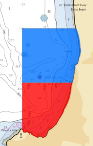

Matlahuayl SMR, La Jolla and San Diego-Scripps Coastal SMCA southern boundary (above) (you can take fin bait in the blue)
Matlahuayl SMR, La Jolla – (Red Area) No fishing. Western boundary extends north from Rocky Pt. The northern boundary is base of Scripps Pier. The San Diego-Scripps Coastal SMCA is directly north.
Boundaries:
This area is bounded by the mean high tide line and straight lines connecting the
following points in the order listed:
32° 51.964′ N. lat. 117° 15.233′ W. long.;
32° 51.964′ N. lat. 117° 16.400′ W. long.; and
32° 51.067′ N. lat. 117° 16.400′ W. long.
San Diego-Scripps Coastal SMCA, La Jolla – (Blue Area) No fishing except baitfish by hook and line. Southern boundary at base of Scripps Pier. Northern boundary is off the La Jolla Farms area, south of the Glider Port. Closed area includes Black’s Beach.
Boundary Description
This area is bounded by the mean high tide line and straight lines connecting the
following points in the order listed:
32° 53.000′ N. lat. 117° 15.166′ W. long.;
32° 53.000′ N. lat. 117° 16.400′ W. long.;
32° 51.964′ N. lat. 117° 16.400′ W. long.; and
32° 51.964′ N. lat. 117° 15.233′ W. long.

Laguna MLPA Complex — Four linked MPA’s make this area a bit confusing. Just remember don’t fish or collect bait in the RED and PURPLE area. In the blue area hook and line and spearfishing are allowed.


Boundaries:


Back in 1967 David and I getting dropped off in the Marineland parking lot with our cane poles for catching opaleye and buttermouth perch. The area that is closed was one of the best and least frequented fishing areas for various rock dwellers. The poop coming out from Marineland’s giant tanks made for a perpetual chum and some very good fishing. Outrageous that it’s closed to anglers now!
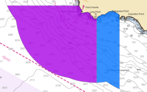
Abalone Cove SMCA, Palos Verdes (Blue above) – No hook and line fishing. Spearfishing for pelagic finfish, bonito and white seabass. Squid ok by dip net only. The eastern boundary runs north-south along the western edge of Portuguese Pt. The western boundary, anchored by Long Pt. seen below, is the southern boundary. Traveling to your right would become White’s Point and San Pedro.

Pt Vicente SMCA, Palos Verdes– (Purple Area) No fishing, no way, no how. The eastern boundary runs north-south from Long Pt. The northern boundary (shown above) is one minor point north of Pt Vincente.
Boundary Description
This area is bounded by the mean high tide line and straight lines connecting the
following points in the order listed except where noted:
33° 44.80′ N. lat. 118° 24.82′ W. long.;
33° 44.80′ N. lat. 118° 28.93′ W. long.; thence southeastward along the three nautical mile
offshore boundary to
33° 41.16′ N. lat. 118° 23.80′ W. long.; and
33° 44.19′ N. lat. 118° 23.80′ W. long.
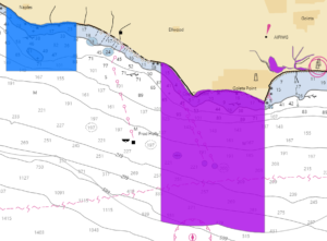
Pt Dume Area (overview map above) – Malibu’s iconic Pt Dume, a mainstay spot for small boaters since time immemorial, is set for complete closure to hook and line fishing. The point itself is surrounded by the Pt Dume SMR. The Pt Dume SMCA to the west allows only limited spearfishing. Sorry Zuma surf-casters, the powers that be made no adjustments for you as they did down south. This was one of the all-time greatest spots for white seabass from shore. Many huge sharks (hammerhead, leopard, seven gill) were taken here before the closure.
Pt Dume SMR eastern boundary at Paradise Cove (Red Above) Permitted/Prohibited Activities:
It is unlawful to injure, damage, take, or possess any living, geological, or cultural marine resource.
 Pt Dume SMR / Pt Dume SMCA Boundary at Zuma Beach (Blue Above) It is unlawful to injure, damage, take, or possess any living, geological, or cultural marine resource, EXCEPT:
Recreational take of white seabass and pelagic finfish by spearfishing is allowed. Commercial take of coastal pelagic species by round haul net, brail gear, and light boat; and swordfish by harpoon is allowed. Includes take exemptions for some tribes.
Pt Dume SMR, Malibu – (Red) No fishing. The eastern boundary runs north-south from Paradise Cove. The western boundary is at Westward Beach Rd / Zuma Beach entrance. The first map shows the eastern boundary; the second, the western, where the SMR meets the adjacent SMCA.
Boundaries:
This area is bounded by the mean high tide line and straight lines connecting the
following points in the order listed:
34° 00.76′ N. lat. 118° 49.20′ W. long.;
33° 56.96′ N. lat. 118° 49.20′ W. long.; thence eastward along the three nautical mile offshore
boundary to
33° 57.06′ N. lat. 118° 47.26′ W. long.; and
34° 01.20′ N. lat. 118° 47.26′ W. long.
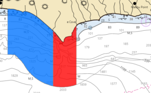
Santa Barbara Area (overview map above) – Several MPAs are clustered around UC Santa Barbara. The largest is the Campus Pt SMR; the nearby Goleta Slough SMCA is also no-take. The Naples SMCA to the west allows only limited spearfishing. Close-up boundary maps and lat / lon numbers are below.
Campus Pt SMCA, (Purple) Santa Barbara area – No fishing of any kind. The nearby Goleta Slough SMCA prohibits fishing, boating, swimming, wading and diving. The eastern boundary runs north-south from Goleta Pt. The western is boundary just west of the Santa Barbara Shores County Park eastern boundary. It is unlawful to injure, damage, take, or possess any living, geological, or cultural marine resource, EXCEPT:
Take incidental to certain permitted activities is allowed. Other restrictions may apply.
Boundaries:
This area is bounded by the mean high tide line and straight lines connecting the
following points in the order listed except where noted:
34° 25.20′ N. lat. 119° 53.60′ W. long.;
34° 21.48′ N. lat. 119° 53.60′ W. long.; thence eastward along the three nautical mile offshore
boundary to
34° 21.21′ N. lat. 119° 50.65′ W. long.; and
34° 24.30′ N. lat. 119° 50.65′ W. long.
Naples SMCA, Santa Barbara area – (Blue) Underwater only, spearfishing for pelagic finfish, bonito, white seabass and nothing else. The eastern boundary is near Eagle Creek; the western boundary is close to Dos Pueblos Canyon Rd. The first map shows the eastern boundary; the second the western. It is unlawful to injure, damage, take, or possess any living, geological, or cultural marine resource, EXCEPT:
Recreational take of white seabass and pelagic finfish by spearfishing is allowed. Commercial take of giant kelp is allowed. Includes take exemptions for some tribes.
Boundaries:
This area is bounded by the mean high tide line and straight lines connecting the
following points in the order listed:
34° 26.51′ N. lat. 119° 58.00′ W. long.;
34° 25.00′ N. lat. 119° 58.00′ W. long.;
34° 25.00′ N. lat. 119° 56.00′ W. long.; and
34° 26.13′ N. lat. 119° 56.00′ W. long.
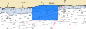
Kashtayit SMCA, Gaviota State Park (above) – Recreational finfish, invertebrates except rock scallops or mussels, and collection of giant kelp by hand are the only allowed takes.
Boundaries:
This area is bounded by the mean high tide line and straight lines connecting the
following points in the order listed:
34° 28.13′ N. lat. 120° 14.46′ W. long.;
34° 27.30′ N. lat. 120° 14.46′ W. long.;
34° 27.30′ N. lat. 120° 12.47′ W. long.; and
34° 28.23′ N. lat. 120° 12.47′ W. long.
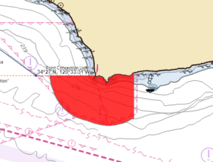
Pt Conception SMR
Pt Conception SMR – No fishing. Eastern boundary near Cojo Road; the northern boundary runs west from Pt. Conception. Just to the west is Jalama Beach, still open to fishing with no closure. From Jalama to Pt. Conception open with good late summer corbina, striper and perch fishing. Rocky areas along this stretch also produce a variety of bass, perch and rock fish. Permitted/Prohibited Activities:
It is unlawful to injure, damage, take, or possess any living, geological, or cultural marine resource.
Boundaries:
This area is bounded by the mean high tide line and straight lines connecting the
following points in the order listed except where noted:
34° 27.00′ N. lat. 120° 28.28′ W. long.;
34° 27.00′ N. lat. 120° 32.15′ W. long.; thence southeastward along the three nautical mile
offshore boundary to
34° 23.96′ N. lat. 120° 25.00′ W. long.; and
34° 27.19′ N. lat. 120° 25.00′ W. long.